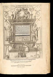
Speculum Nauticum
Spiegel der Zeevaert, Latin edition of Lucaz Janszoon Waghenaer
Type of object:
Atlases
Time period:
Gouden eeuw Nederland
Place:
Antwerp
Date:
1591
Maker / Author:
Waghenaer Lucas Janszoon. Mariners pilot or Rutter with 46 maps of the first rutter for seafarers. Atlas Editie WAG 9A
Publisher / Printer:
Jean Bellerum in Antwerp
Dimensions:
430 x 299 x 34/86
Material:
Copperprints on paper, original vellum band with goldprinting
Graduation:
Inscription:
Speculum Nauticum
Provenance:
Amsterdam
References:
Koeman pag 465- 493 Daniel Crouch rare books

Description
The first volume of the Spieghel contains instructions on various navigation techniques and the use of the manual, and maps of coasts from Texel to Cadiz, each accompanied by a coastal profile. Portuguese navigators had pioneered the use of coastal profiles in navigation, but Waghenaer was the first to include them for every chart on a consistent scale. The second volume, published a year later, contained charts of the coasts north of Texel. They were engraved by Johannes van Doetecum, one of the finest workers of the age. The charts were based on Waghenaer’s own extensive experience, supplemented by manuscript and printed sources. The accompanying text was based on other sixteenth century navigation manuals. It was a revolutionary success, and was translated into German, Latin and French, as well as an unauthorised English edition. His work was so popular in England that the Anglicized version of his name, “Waggoner”, became a generic term referring to sea atlases and charts. (Daniel Crouch)
Additional information


